The Hurstbridge Line is a commuter railway line in the city of Melbourn. It is the city's seventh longest metropolitan railway line at 36.7 kilometres. Sections of the Hurstbridge Line opened as early as 1888, with the line fully extended to Hurstbridge by 1912. The line was built to connect Melbourne with the rural towns of Greensborough, Eltham, and Hurstbridge, amongst others. Since the 2010s, due to the heavily utilised infrastructure of the Hurstbridge Line, significant improvements and upgrades have been made. An upgrade of the corridor from Heidelberg Station onwards began construction in 2016 and mostly completed by 2023, with improvements including the removal of level crossings, rebuilding stations, and the duplication of more than 4.5 km of track.
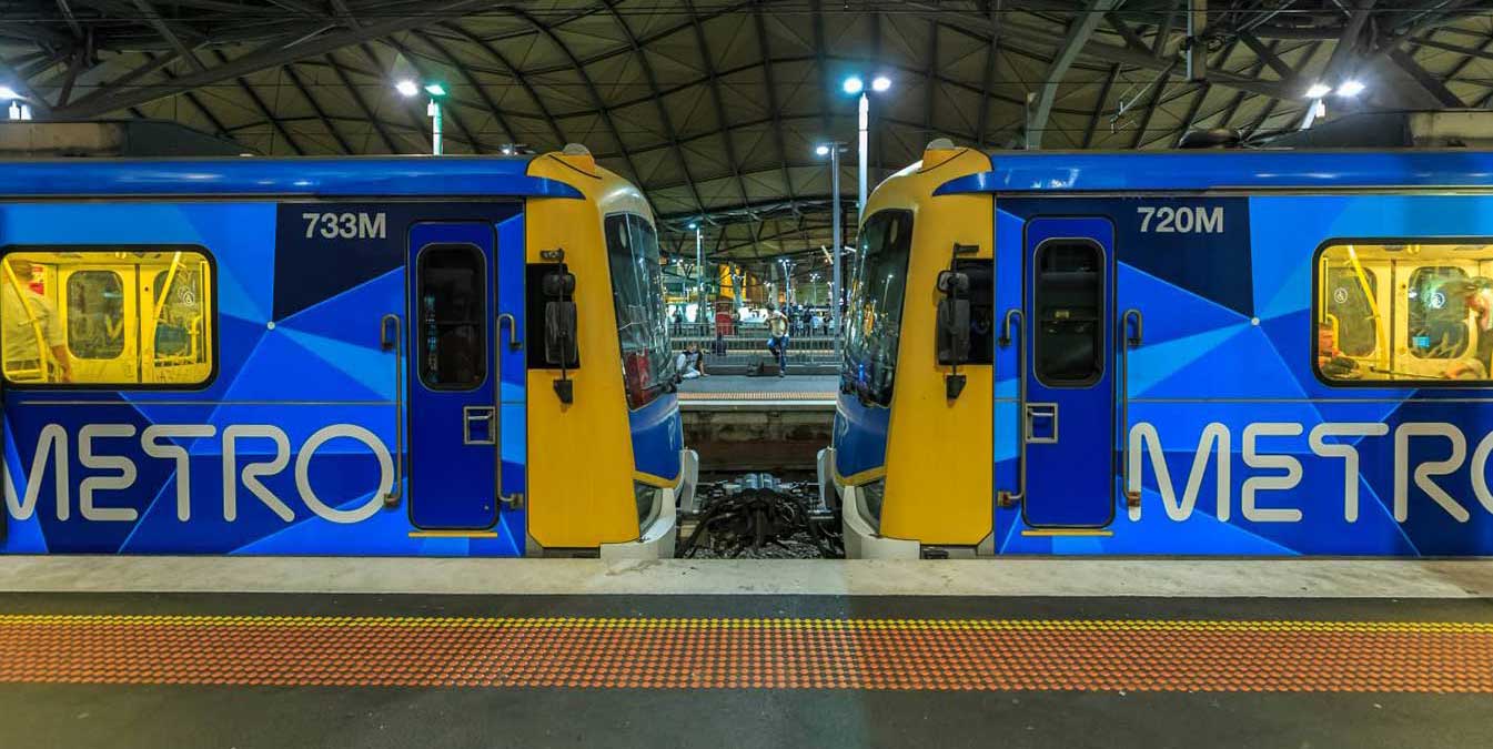
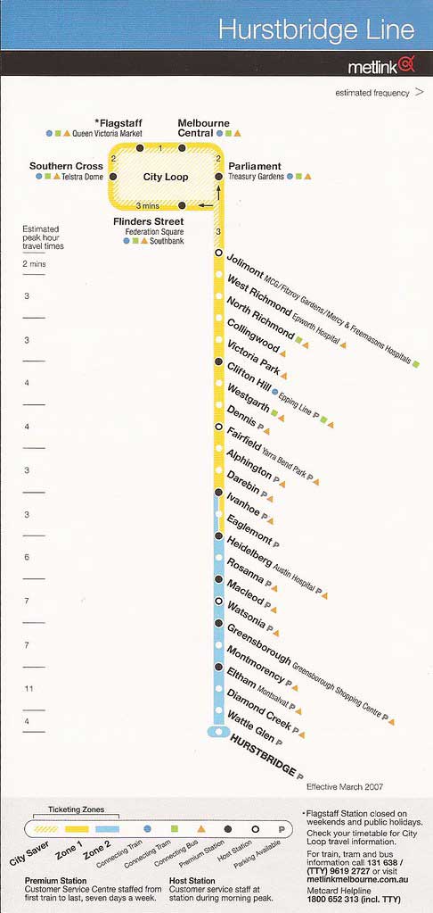
The line runs from Flinders Street Station in central Melbourne through the City Loop to Hurstbridge Station in the north-east, serving 28 stations via Clifton Hill Station, Heidelberg Station, Macleod Station, Watsonia Station, Greensborough Station, Eltham Station, and Diamond Creek Station. The line operates for approximately 19 hours a day (from approximately 5:00 am to around 12:00 am) with 24 hour service available on Friday and Saturday nights. During peak hour, headways of up to 15 minutes are operated with services every 20–30 minutes during off-peak hours. Trains on the Hurstbridge Line run with a two three-car formations of X'Trapolis 100 trainsets.
The underground City Loop is at the centre of Melbourne's busy suburban railway system. It's quite an unusual design, being made up of four completely independent single track tunnels, some of which change direction half way through the day. From Flinders Street station, trains travel across the Flinders Street Railway Viaduct to Southern Cross Station. Upon leaving Southern Cross, trains travel underground through Flagstaff. Melbourne Central and Parliament stations, emerging from the underground loop at East Melbourne.
Jolimont is a residential precinct in East Melbourne, 1.5 km. from the GPO, Melbourne. In 1839 Charles Joseph La Trobe arrived in Melbourne as the Superintendent of Port Phillip. He brought a transportable dwelling and was obliged to buy land on which to erect it. Jolimont developed into a quiet residential precinct, until 1889, when a warehouse was erected in Agnes Street, and ten years later it became the Bedggood Boot Factory.
In 1887 a railway line was laid along the wide Wellington Parade reservation, and the Jolimont station was opened in 1901. A major railway yard was developed alonside the line. Located between Flinders Street station, Richmond Junction, the Yarra River and Flinders Street the yard and associated workshops were used to service and store suburban passenger trains. Often criticised for cutting off the city from the river, it was sybject to many redevelopment proposals. The rail sidings were progressively removed from the 1980s to the 1990s with only running lines today, but the area continues to be referred to as the 'Jolimont railyards' by Melburnians, however the railway interchange located there today is actually called Richmond Junction.
Jolimont station, which lies beyond the junction on Wellington Parade, East Melbourne, was opened on 21 October 1901 when a direct railway line was provided between Princes Bridge station (located on the site of Federation Square) and Collingwood. Jolimont is one of two stations that are close to the Melbourne Cricket Ground (MCG), the other being Richmond. During events at the MCG, extra exit gates are open to reduce crowding. The original timber station building was manufactured in England in 1899. In the late 1920s, it was sold and re-erected in Canberra, on the site of the present Jolimont Centre.
The Mernda line passes through the Jolimont Tunnel under Freeman Street and the West Richmond Tunnel under Hoddle Street. Most road users or pedestrians wouldn't know that they going over these tunnels. Before their construction in 1901 the only access was via the Inner Circle line.


West Richmond railway station serves the inner eastern Melbourne suburb of Richmond, and it opened on 21 October 1901. The station opened along with the line from Princes Bridge to Collingwood. Richmond, 3 km. east of Melbourne, has been a residential, industrial and residential, and latterly a more residential, suburb. Its western boundary, Punt Road, adjoins Melbourne city and its eastern boundary is the Yarra River, across from leafy Hawthorn. Richmond has a prominent hill on its western boundary, known as Richmond Hill but also as Dockers Hill. It is surmounted by four church spires. The land falls away to the river in the east, to the Collingwood flat in the north and to the flat land of Burnley n the south.
North Richmond, opened on 21 October 1901, is an elevated station with two side platforms, each with a pebbledash station building. It serves the western end of the Melbourne suburb of Richmond. Between West Richmond and Clifton Hill stations, the line follows Hoddle Street on it eastern side.
Collingwood is one of the oldest suburbs in Melbourne, notable for its historical buildings, with ornate, historic public buildings, cottages, terraces, shops, warehouses and factories still in use. Once a not-so-family-friendly part of town, known more for being the stomping ground of infamous gangsters like Chopper Read, Collingwood has had an extensive makeover, transforming it from a characterful, sometimes sketchy, suburb into an artsy, stylish neighbourhood with a thriving bar and dining scene.
These days Collingwood is about award-winning restaurants, great bars, galleries and mid-century furniture stores. The busy nightlife and close proximity to the city has attracted the independent types, the majority being young singles or more mature and older people living an inner-city lifestyle. Its redidents are comfortable with compact, convenient living, with housing ranging from workers cottages, bluestone terraces, Housing commission high-rises, converted factories housing designer apartments and live-in warehouses, to new contemporary units and townhouses.
Victoria Park station takes its name from a sports venue in the suburb of Abbotsford. The stadium is oval shaped and was built to host Australian rules football and cricket matches. In the past Victoria Park featured a cycling track, tennis courts, and a baseball club that once played curtain raisers to football matches. At its peak, from 1959 to the late 1980s, Victoria Park was the third largest of the suburban VFL stadiums after the Melbourne Cricket Ground and Princes Park. The ground is made up of
Victoria Park station opened on 8 May 1888 and, until 1901, the station was the terminus of the Collingwood to Heidelberg railway line. Until a direct connection with the Melbourne CBD was opened in 1901 between Princes Bridge and Collingwood Town Hall, the only connection to the city centre was via the indirect Inner Circle line.
Clifton Hill is a residential suburb 4 km north-east of Melbourne, separated from Collingwood by Alexandra Parade and the Eastern Freeway. An early landowner, better known in Richmond, was John Docker, who owned Clifton Farm in 1841. A land speculator, John Knipe, later named the area Clifton Hill.
The Melbourne City Council operated a basalt quarry in Clifton Hill, between Yambla Street and the Merri Creek, in the 1850s, continuing until the 1950s. Most of the other land was held by the Crown for agistment purposes, and Government land sales began in 1864. Residential settlement ended the use of Clifton Hill for the burial of sewage in the 1870s. The railway line only connected Collingwood and Heidelberg until a link between Princes Bridge and Collingwood was opened in 1901. A local shopping strip grew along the tramline on Queens Parade.
Westgarth is a residential suburb where the tram and train services cross the Merri Creek, south of Northcote, 5 km. north-east of Melbourne. Land sales occurred in Northcote in 1840, but the land between Westgarth Street and the Merri Creek was withheld, probably as a reserve for a township in view of its proximity to water. In 1853 a township was gazetted, to be called Northcote.
A railway line was opened in 1884 from Clifton Hill to Alphington, via Northcote South. Four years later it was linked to Melbourne, although by a circuitous westerly loop that terminated at Spencer Street. Two years later the High Street tramline opened, only to close twice before reopening permanently in 1901. During the period 1906-10 the railway station was named Westgarth, and the area took on that name. Being only a short way beyond Clifton Hill, and having rail and tram services, Westgarth was eminently suitable for residential settlement by the turn of the century, and development boomed. Its housing is mostly Victorian and Edwardian, with a smattering of California bungalows.
Dennis railway station serves the north-eastern Melbourne suburb of Northcote. Opening on 4 February 1924, Dennis station is named after Northcote Councillor William Dennis, a member of the council for over 40 years. In 1964, boom barriers replaced hand-operated gates at the Victoria Road level crossing, located nearby in the down direction of the station. The current station buildings were erected in 1979.
Fairfield, a residential and industrial suburb east of Northcote, is 6 km. north-east of Melbourne. It includes a southerly portion surrounded on three sides by meanders of the Merri Creek and the Yarra River, chiefly consisting of open space and once containing institutions dating from colonial times, notable the Yarra Bend asylum. Land sales in the Fairfield area were included in those extending from Northcote to Alphington in 1840. The early villages were Alphington and Northcote (where today's Westgarth is situated).
In 1888 the railway line through Fairfield Park, from Collingwood to Heidelberg, was opened, and Fairfield Park was the junction of the Outer Circle railway from Oakleigh (1891-93). In the early 1880s a land speculator, Charles Henry James opened a tram service along Station Street, from the station to Mansfield Street running from 1884 to 1890, connected to the railway line that between 1884 and 1888 ran only from Clifton Hill to Alphington (the line from "no where to no where"). Fairfield was thus launched with a high degree of attention to public access, and the house blocks sold well. They were reasonable value for money in that they were bigger than the standard blocks closer to Melbourne.
Alphington is immediately north of the Yarra River, some 7 km. north-east of Melbourne. On its west is Fairfield and on its east is Ivanhoe. Farm-size land sales in Alphington coincided with those in the Northcote and Fairfield district in 1840. By 1865 Alphington was mainly occupied by market gardens, and vineyards, with a post office, butcher, baker, general store and two hotels, one being the Darebin Bridge. At the time, the Heidelberg Road was a route to gold diggings at St. Andrews and in upper Gippsland. The Wesleyan Chapel was built in 1859 and survives as part of the Uniting Church's group of buildings. Alphington is today a primarily residential suburb consisting of mixture of 1970s brick veneer, recently built townhouses as well as period weatherboards.
Darebin is a residential locality 8 km. north-east of Melbourne, immediately west of Ivanhoe. It is situated on the Darebin Creek a tributary of the Yarra River with headwaters at Woodstock. The Darebin Creek was shown on a 1839 survey plan, defining the western border of the Parish of Morang. A map of Warringal (Heidelberg Village) had a Darebin Street, in the same year. It is thought that the name is derived from an Aboriginal word meaning swallow (bird).
.
Rockbeare Park (part of the Rockbeare property), on the east side of Darebin Creek was entrusted to the Heidelberg shire in 1888 and is joined by a footbridge to the Darebin Parklands. Until 1888 the north-eastern suburbs had no rail connection to Melbourne. In that year lines from Heidelberg to Collingwood and then from Collingwood via a westerly loop to Melbourne were opened. Part of the Rockbeare property, north-east of the present park, was subdivided into 88 lots when the railway line was opened.
Ivanhoe is a residential suburb 9 km. north-east of Melbourne, south of Heidelberg. The land occupied by Ivanhoe was one of several portions adjoining the Warringal (later Heidelberg) village surveyed in 1837. Sales occurred the following year and, the Ivanhoe portion was considered to be of unusual fertility and landscape appeal. It had Darebin Creek on the west and the Yarra River on the south. By the 1850s there was an Ivanhoe village, a name derived form Sir William Scott's novel, and used from 1853. Between 1910 and 1930 Ivanhoe underwent extensive residential development.
Eaglemont is an elevated residential suburb 10 km. north-east of Melbourne. It is part of Ivanhoe. The name is probably derived from Mount Eagle, a Crown Grant property acquired by Thomas Walker, N.S.W., in 1838. Walker was the author of "A Month in the Bush of Australia" (1838) and he was one of the representatives of the Port Phillip District elected to the New South Wales Legislative Council in 1843. He sold the property to John Browne, father of the author Rolfe Boldrewood.
Until the turn of the century Eaglemont was a place of large estates and scattered houses. The depression caused some houses to be vacated, and the plein air school of painters were able to cheaply rent one at the Mount Eagle Estate, shortly after railway access was made possible by the extension to Heidelberg in 1888. Mount Eagle and the surrounding area were already renowned for fine views and appealing landscape.
As Ivanhoe underwent rapid subdivision in the years before the first world war, Eaglemont was something of an elevated country retreat. A golf club was established in 1898, leaving the site in 1910 for one near the Rosanna railway station. In 1915 Walter Burley Griffin laid out an estate of three streets (Glenard Drive area), and other subdivisions bear evidence of his landscape ideas. When the Eaglemont and Mount Eagle estate was subdivided for housing the advertisement stated that all streets were one chain wide and planted with choice English trees. Any house to be erected was restricted to a value of 750 pounds of more, two or three times the cost of more modest houses. That restriction has been maintained either by caveat or custom.
Heidelberg is principally famous for its associations with a crucial aspect of Australia's art history. In the mid-1880s a loose association of painters, including Arthur Streeton, Tom Roberts, Frederick McCubbin, C.D. Richardson, Charles Conder, Walter Withers, Jane Sutherland, Clara Southern and Emma Boyd (the wife of Arthur Boyd) began adapting the ideas of the French impressionists to Australian conditions.
Often painting in the open air to capture the nature of Australia's light, colour and atmosphere, they initially carried out much of their experimental work at Box Hill. The group (with the exception of McCubbin) moved on to Eaglemont at Heidelberg later in the decade, thus acquiring the name "The Heidelberg School". It was largely through Tom Roberts that the new pictorial ideas, theories, techniques and sensibility were imported from Europe.
The rich river flats in the area drew attention from pastoralists, market gardeners and orchardists soon after Melbourne was established in 1835. The first land sales occurred in 1838 and Heidelberg was already well settled by 1841 with timbercutters at work, dairy farmers along the creeks and gentleman farmers on larger estates. Small farmers moved in, growing first wheat then, later, oats, potatoes, vegetables, barley, lucerne, maize and hops and establishing market gardens, orchards and vineyards. In the early years of the 20th century, these gave way to residential subdivision. Heidelberg was declared a city in 1931. An interesting footnote to the history of Heidelberg is the fact that a famous 100-minute film about the Kelly gang was filmed at the local Charterisville estate in 1905. A three-minute remnant was rediscovered in the 1980s.
Like many estates built during the public housing shortage of the early 1950s, the Olympic Village for the 1956 Melbourne Olympic Games in West Heidelberg was built fast, but still only just in time to serve its immediate purpose. The Village was built by the Housing Commission to house the 6,000 athletes and officials participating in the 1956 Olympic Games in Melbourne. At the end of the Games, the Village was used to permanently accommodate families in need of housing. Some flats were still being finished as athletes from around the world arrived to take part in the Games.
Rosanna is a residential suburb 12 km. north-east of Melbourne, about 2 km. beyond Heidelberg. In 1838 the land around the Warringal (Heidelberg) village was divided into nine portions of between one and two square miles. Portion 5, one of the largest, immediately north of the village reserve was sold to James Watson. He named it Rosa Anna farm after his wife, Elizabeth Anna Rose. Watson soon subdivided and sold lots from his Rosanna Estate, although about four-fifths of Portion 5 remained as an intact estate in the early 1890s.
One reason for this was that Heidelberg did not achieve a railway connection until 1888, and then only to Collingwood: a commuter had either to take a tram from Collingwood to Melbourne or continue by train by a westerly route. A direct train link was made in 1901, and the extension of the line past Heidelberg, through Rosanna and on to Eltham was made the following year.
Macleod railway station was opened to traffic on 1 March 1911. A number of train services terminate at Macleod, before proceeding to the sidings to stable. The station is named after Malcolm Anderson Macleod, a prominent local resident, whose wife Edith Jessie Macleod purchased land in the area. The press of the time credited Edith Macleod's husband with owning the land but this was not the case. On 25 October 2022, the Level Crossing Removal Project announced that the Ruthven Street level crossing, located nearby in the up direction of the station, will be grade separated by 2027, with the railway line to be rebuilt over the road.
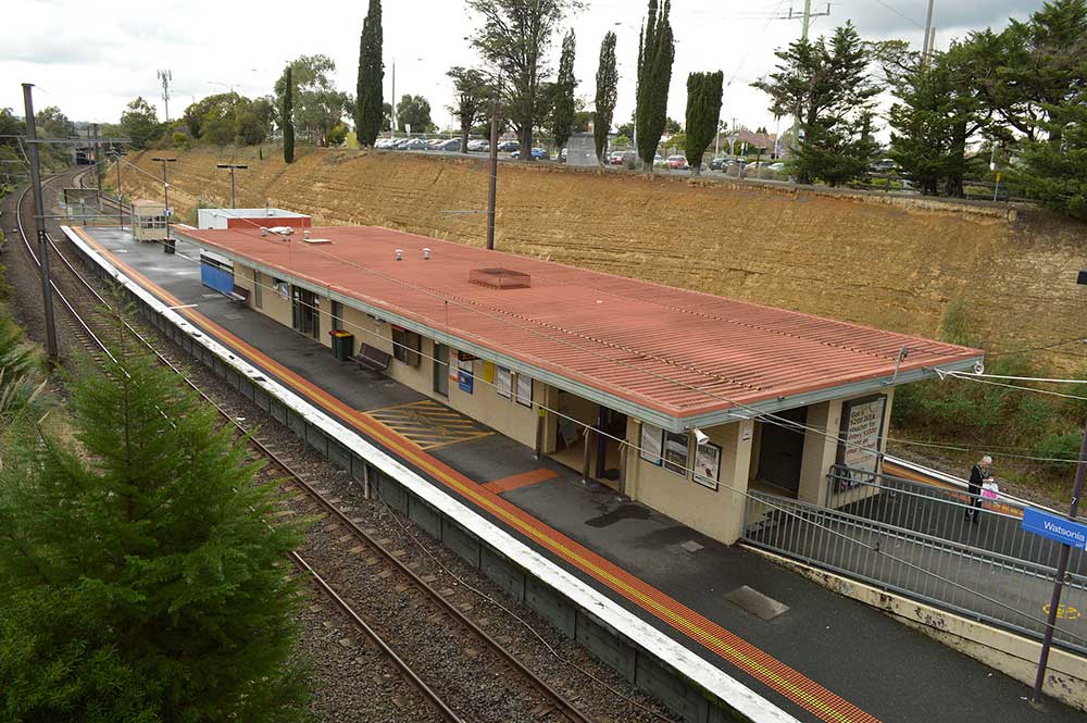
Watsonia, a residential suburb south-west of Greensborough, is 15 km. north-east of Melbourne. Like Heidelberg and Greensborough, Watsonia was surveyed in 1838 for subdivisional sale as farms. The area remained rural well beyond the extension of the railway through the area (1902), as a station was not built until 1924. In that year local land owners, of whom one was Frank Watson, marketed the Grace Park Station Estate, Grace Park being the property from which Watson's land was subdivided. The station was paid for by the promoters and the Heidelberg council named the station Watsonia.
The area became best known for the Watsonia Military Camp during the second world war. The camp was handed over to the State Housing Commission for emergency housing and in 1947 a temporary primary school was ened. In 1952 the Department of the Army resumed the camp for National Service Training. The area is now known as the Simpson Army Barracks, Yallambie, and is divided from Watsonia by a postcode boundary and previously by the boundary between Heidelberg city and Diamond Valley Shire (1963-94). During the 1980s the barracks came under protest as a site for the American military space satellite network.
Greensborough is a residential suburb 17 km. north-east of Melbourne, situated on the Plenty River. The land around Greensborough is hilly, and during Port Phillip's pastoral expansion it was not highly sought after apart from the areas adjoining streams or other well watered areas. It was part of the subdivision by the government surveyor, Robert Hoddle, in 1838. The section comprising most of present day Greensborough was purchased by Henry Smythe who sold it in 1841 to Edward Green, soldier, squatter and mail contractor.
By 1868 Greensborough had an Anglican church with a primary school (1855), a store, a post office, a hotel and a local population of about 200. The Road District's population was about 670. In January, 1875, the Roads Board succeeded in amalgamating its area with Heidelberg shire, motivated by its difficulties in maintaining the roads. A state primary school replaced the Anglican in 1878. In 1902 the railway line was extended from Heidelberg to Eltham, with a station at Greensborough. The township's estimated population was about 270. There was a steady growth of population after the railway extension, but the area was predominantly rural until the postwar years because of the undeveloped areas suitable for inter-war housing closer to Melbourne.
Montmorency is a residential locality 18 km north-east of Melbourne between Greensborough and Eltham. It was named after a farm, the Montmorency estate, which was named after the French town where J.J. Rousseau lived. The first evidence of a township was the building of a Presbyterian church in 1917 in the midst of small rural landholdings. A primary school was opened in 1922, the year before the station was opened on the railway line to Hurstbridge. Electricity was connected to the area in 1926. Whilst there was a residential nucleus from the 1920s, most of Montmorency consisted of orchards, dairying and poultry farms until after the second world war. The estimated population in 1922 was 200, including weekenders.
Eltham is 20 km north-east of Melbourne. It was surveyed as a village in 1840, near the junction of the Diamond Creek and the Yarra River, coinciding approximately with the track marked by the Ryries to provide access from their property near Yarra Glen to the Heidelberg village. The name probably derives from one of several Elthams in England. In 1857 town allotments were sold in both the surveyed site and a little northwards. The latter was promoted by a speculator as Little Eltham and it sold better and influenced the ultimate town centre. During the period of the Caledonia Diggings (centred on St. Andrews and Panton Hill), Eltham's population grew as the town became a food, produce and supply centre for the mining communities (1860s - 1880s).
A post office was opened in 1854 and a flour mill, brewery, brick works and tannery later in the decade. There were also two churches, a primary school (1856), a police station and a court house. Eltham also became a stopping place en route to the Woods Point Diggings. In the 1880s agitation began for extension of the railway from Heidelberg, to serve Eltham and districts further afield such as Kangaroo Ground. The extension came to Eltham in 1902, but never to Kangaroo Ground.
The creek is a tributary of the Yarra River joining it at Eltham. The Creek's headwaters are in the Kinglake ranges, just beyond St. Andrews. Its name probably came from crystalline minerals observed on the bed of the creek. The township of Diamond Creek is 23 km, north-east of Melbourne, just above Eltham, where Arthurs Creek joins Diamond Creek. Settlement was attracted to it rather later than the more open areas of the Plenty River and the Yarra River, and the first white inhabitants were mostly timber getters and paling splitters. Gold seekers opened up the Caledonia diggings further upstream in 1855, which were named after the Caledonia run (1841) situated near where the Diamond Creek township was later created.
In 1863 the Diamond Reef was discovered resulting in substantial gold mine workings, which coincided with the formation of the township. A post office, Methodist church and a school were established by the following year. In 1886-7 the township was surveyed and named Nillumbik - the name of the Parish and the town's town name which continued to be used until the turn of the century. The area became a mixture of bushland and small farms, and orchards had a period of strong prosperity from the mid 1880s to about 1912. A horticulturist society was formed in 1884
Wattle Glen, a mostly rural locality on the Diamond Creek, is 25 km. north-east of Melbourne, between Diamond Creek and Hurstbridge. Its name arose from the wattle trees which are still profuse in the area. It is on the railway line which was extended from Eltham to Hurstbridge in 1912 and electrified in 1926. A primary school was opened in 1922.
Until the 1980s Wattle Glen was rural. The local commercial and shopping centre was at Diamond Creek or Hurstbridge, and by the mid 1990s only a general store was available for closer shopping. Nevertheless, residential subdivision was filling the space between Wattle Glen and Diamond Creek, whilst the sparser housing northwards remained much the same. The name us descriptive and was first used for the residential subdivision.
Hurstbridge, once an apple growing district, is now a residential suburb 26 km north-east of Melbourne. It is on the Diamond Creek and is the terminus of a railway line from Melbourne. Its name was formerly Hurst's Bridge, named after Henry Hurst who was an early settler murdered by a bushranger in 1866. Hurst had occupied a property called Allwood, and his descendants continued to do so. When the railway line was extended from Heidelberg in 1912 the railway station was named Allwood.
At that time Hurstbridge had a public hall, a saw mill and a cool store for local orchardists. Hurstbridge is said to hold the Australian record for the most apples dispatched from a railway station in one season. A primary school was opened in 1916. Hurstbridge was also a tourist resort, and a recreation reserve, croquet green and tennis courts were added by 1940.


Design by W3layouts