The Main Southern Railway commences as an electrified pair of tracks in the Sydney metropolitan area. Since 1924, the line has branched from the Main Suburban railway line at Lidcombe and runs via Regents Park to Cabramatta (now the Regents Park branchline), where it rejoins the original route from Granville. The line then heads towards Campbelltown and Macarthur, the current limit of electrification and suburban passenger services.
The line continues as a double non-electrified track south through the Southern Highlands towns of Mittagong and Goulburn to Junee on the Southern Plains. Here the line becomes single track for the remainder of its journey south to the state border with Victoria at Albury. The North East railway line then continues through northern Victoria to Melbourne. There are six tunnels on the line: the Picton tunnel, the Yerrinbool tunnel, the Aylmerton tunnel, the Gib (Mt Gibraltar) tunnel, and the two "up" track tunnels in the Bethungra Spiral.
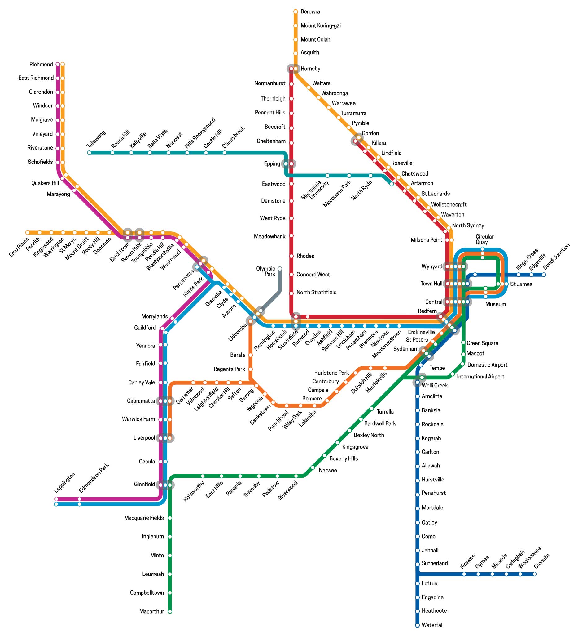
As it is part of a series on Sydney's suburban railway system, this article focuses in on that section of the line between Lidcombe and Macarthur.
Note: suburban passenger trains from Sydney Central station to Macarthur now travel via the Airport Line, East Hills Line and the Main Southern Line from near Glenfield to Macarthur (T8). Bankstown line services (T3) travel on the Regents Park branchline.
The Inner West & Leppington Line service (T2) runs on sections of the Main Southern Line. Consisting of 37 stops, the service commences from the City Circle, then heads west to Granville. The line branches at this point; services either head northwest to Parramatta or south to Leppington via Liverpool and Glenfield.
The area was first known as Haslam's Creek after Samuel Haslam who took up a grant here in 1804, the northern boundary of which was the creek which bares his name. His neighbours included Joseph Potts, an accountant of the Bank of New South Wales, after whom Potts Point is named. He called his 1,000 acre grant Hyde Park. Potts extended it several times to include what today are Berala, Rookwood, Auburn and Potts Hill, which recalls its former owner.
Haslam's Creek, located near the site of Lidcombe station, was one of the first stations on the Sydney to Parramatta railway in 1855. Three years on it was the site of the first major railway accident in New South Wales which resulted in two deaths. When Rookwood Cemetery was opened in 1867, it was named Haslam's Creek Cemetery but the name was changed in 1876 after residents complained that the name associated their suburb with the cemetery. Ironically, when the cemetery's name was changed, so was the railway station - it became Rookwood! To add insult to injury, the municipality of Rookwood was created in 1891 which led to more lobbying to change the name back. This led to the selection of a new name for the suburb and railway station - Lidcombe - which was gazetted in 1913.
The name Lidcombe was created in 1913 by joining sections of the names of two mayors of the Municipality of Rookwood: Mr Lidbury, the then current mayor, and Mr Larcombe, a former mayor.


The area was originally part of Liberty Plains, a name reflects the fact that its first white occupants were free settlers or NSW Corps retirees rather than convicts who were known as Liberty men and women. Farms did not give way to urban development until after 1912 when the railway station was opened. The area surrounding the station was swampy marshland where wildlife abounded, in particularly native musk ducks or 'bareela', and it was for this reason that the name was chosen.
Scattered farming was the extent of activity by white settlers before the area was subdivided and sold as small farms in 1880. At the time, an existing local property here had been named Regent's Park by its owners, Messrs Peck and Jackson- after the locality in London. It was known first as North Bankstown, then in 1906 it became Sefton Park. A railway station, named Sefton Park East Junction, was opened in 1914 when the Bankstown railway line was brought into service. The station was moved to its present location when the Regents Park to Liverpool branch line was opened in October 1924 and renamed Regents Park, though the area had had yet another name change four years earlier, to Sefton. In May 1929 the name was standardised as Regents Park.
Contrary to popular belief, there is no one named Chester after whom this locality was named. The area was called Boroya by the Aborigines, but this was not known to railway authorities when they went looking for a name for their new station here. They approached the local residents for suggestions and one of them, a Miss H.A. McMillan, came up with a number of suggestions which she passed by her neighbours. These included Hillcrest and Hillchester, after a town in England she had visited and had an affection for, but the suggestion was rejected. She inverted the name, making it Chester Hill, and it won favour and was adopted. Brief history: the first white settlers developed the area as market gardens and orchards. When the Regents Park railway came through in 1924, light industry and residential development began.
Leightonfield is a railway station at Villawood on the Regents Park to Cabramatta line. The origin of the name is not known. A light industrial area, Leightonfield is the location of National Rail's Sydney marshalling yards.
In terms of European settlement, Villawood was a slow starter. The first grant, of 1,000 acres, did not occur until 1823. It was to John Thomas Campbell who named his orchard Quid Pro Quo. By the 1860s most of the land was occupied by orchards though the area was overrun by wild dogs, which gave rise to the main road through it being called Dog Trap Road (Woodville Road).
When the railway station was opened in 1922 the name Woodville was suggested - as Woodville Road passed through it - but it was felt it would be confused with Woodville near Newcastle. Someone playing around with variations of the name swapped the first syllable with the second and came up with Villawood, which was adopted. For some inexplicable reason, when the local school opened in October 1824, it was named Mark Lodge. The ensuing outcry made sure it took only two months to change it to Villawood. The Westbridge Migrant Centre, now the Villawood Immigration Detention Centre, is in Villawood.
Its name - from an Aboriginal word meaning 'shade of trees' - indicates the area was once covered in forest. Land here was to be leased for farming in August 1803 though it appears it remained in the hands of a single owner until its subdivision into smaller farms in 1885. When the railway between Sydney to Campbelltown was built in 1856, the area was already known as Carramar. Its station, however, was first called South Fairfield and it wasn't until 1926 that its present name was officially adopted. In that same year the Villawood Post Office had its name changed to Carramar as it fell within the boundary of the newly created suburb.
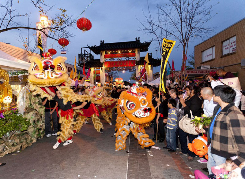
Cabramatta is a name of Aboriginal origin - 'cabra' (an edible freshwater grub) and 'matta' (place of). A suggestion has also been made that it means 'place at the headwaters' though it is more likely that it is the Aboriginal name for the place at the headwaters (of Cabramatta Creek, which Cabramatta is), which was called Cabramatta, meaning " place where cabra (edible freshwater grub) are found.
Cabramatta's first white settlers were Irish political prisoners who established a camp here. In 1803 a huge tract of land was given to Rev. Samuel Marsden and others to establish an orphanage. The area developed as a prosperous farming community until the arrival of the railway in the 1880s when subdivision began. It is today the centre of Sydney's Vietnmese community.
Among the first European occupants of land here were Irish political prisoners transported to New South Wales because of their involvement in the Irish rebellion of 1798. Grants were made to other transportees, many of whom were not criminals as we understand the term today, having opposed the government on matters of national interest.
Warwick Farm racecourse came into being as a result of numerous farms in the area breeding horses and a course was created to race them. The first race meeting was held in 1889. During World War II, huts were built to create the British Navy shore base HMS Golden Hind. After the war the huts were used as emergency accommodation and named Hargrave Park. Shops and houses now occupy its site.
Warwick Farmis named after the town of Warwick in England by John Hawley Stroud, the superintendent of the Liverpool Orphans School who received a grant covering the site of the Warwick Farm racecourse. He gave the name to his farm and it was later adopted for the whole area.
Liverpool is one of a number of towns founded by Gov. Macquarie as a centre for the developing areas to the west of Sydney. At the time of Macquarie's visit, there were already numerous farms established in the area then known as Cow Pastures which is between Liverpool and Camden. Liverpool town centre contains a number of historic buildings dating from Macquarie's time. It remained a centre for a thriving dairy farming industry until well after 1856 when the railway arrived, however from that year it grew significantly as a residential area.mLiverpool was named in honour of Robert Jenkinson, the Earl of Liverpool who, at the time of naming, was Secretary of State for the Colonies and later Prime Minister of England.
The suburb of Casula's main claim to fame occurred during World War II when a company of 5,000 soldiers stationed here rioted after having their training conditions changed. The soldiers embarked on a drunken brawl which took them into the Sydney city centre, damaging shops, homes and private property on the way. After a night of destroying shops in the city centre, they sobered up the next morning and all but 15 gave themselves up.
Casula takes its name from the property of land grantee Richard Guise, named after the place where he had lived in England. Another grantee was Ebenezer Bunker, a leading businessman in the young colony whose first contact with it was as master of the William and Anne, carrying 188 convicts of the Third Fleet. Bunker saw the colony's potential and returned, establishing numerous businesses including a successful whaling operation.
Glenfield takes its name from a 1500 acre grant, it was named after the village of Glenfield near Leicester, England, the birthplace of grantee and explorer Dr. Charles Throsby, a naval surgeon. Throsby served on Norfolk Island and at Newcastle and was awarded this land grant on his retirement. Ironically, none of present day Glenfield is part of the original Glenfield grant. The Glenfield property was located further north, near Casula, and only came as far south as The Crossroads.
In the 1880s, a railway platform named Glenfield was on the original Glenfield grant and stood close to where the East Hills line branches off the main southern line today. The platform was rarely used so in 1891 it was decided to move this now disused platform down the line to a new subdivision. The Glenfield name was retained for the station and applied to the new housing estate. Glenfield saw its greatest development as a residential area after World War II. Many of Glenfield's streets were named after early residents and family members of the developers. The streets of a 1970s subdivision are named after locations in New Guinea as a result of the town planner involved in the development having been a patrol officer in Papua New Guinea.
Macquarie Fields was named after Macquarie Fields House, in honour of Lachlan Macquarie, Governor of the colony of NSW, 1809-1821. Much of Ingleburn and Macquarie Fields were part of the first land grant in the area, the recipient of which was James Meehan (1774-1826) who took possession in 1810. Gov. Macquarie always referred to it as Meehan's Castle. Meehan was an emancipated Irish convict who got caught up in the Irish Rebellion of 1798. Macquarie made him Deputy Surveyor of Lands and later Superintendent of Roads and Bridges, appointments that raised the ire of free settlers who objected to the elevation of former convicts to positions of authority in the colony.
Samuel Terry took over the property in 1835 died 3 years later, leaving the old Meehan grant to his daughter, Martha, for whom it is believed Macquarie Fields House was built. The area was subdivided into smaller farms soon after but remained farmland until the 1970s when its residential areas were developed by the Housing Commission. Its streets are named after Australian native trees and shrubs.
The area was originally known as Soldier Flat, because this was where four soldiers of the NSW Corps took up farm grants in 1809.With the coming of the railway, a platform was built on the grantee William Neale's property, at the current site. Originally called Macquarie Fields, its name was changed to Ingleburn when the new village of Macquarie Fields was separated as part of a new subdivision. Many of Ingleburn's earlier streets have English connections, however many of the newer streets are named after birds and those towards the Georges River are named after makes of cars.
In 1939, the Australian Government purchased some 648 acres for about £20,000 from a Farmer MacDonald, for the Bardia Barracks. The land was part of the Denham Court Estate. A memorial pays tribute to the people who trained here and those who lost their lives in active service.
The origin of the name is not known. It is thought that the first white settler in the area, Richard Atkins, may have named his grant Ingleburn in 1793 after his hometown of Ingleburn in Devon, England. Atkins became NSW's second Advocate General after David Collins, returning to England with Bligh in 1809. Alternatively, the name may be derived from the Gaelic 'inge' (bend) and 'burn' (river). There are two very distinct bends in the Georges River where it forms Ingleburn's eastern boundary. Gov. Lachlan Macquarie was born and bred in the Gaelic-speaking Scottish Highlands and could have named the area during his first visit to it in 1810.
Minto was named in honour of Gilbert Elliott Murray-Kynynmond, Earl of Minto, British Governor-General of India (1807-13), by Gov. Macquarie under whom he had served before coming to Sydney. Dr. William Redfern, the first doctor in charge of Macquarie's rum hospital, was the first grantee in the area, and built a farmhouse here which he named Campbellfield. He retired here in 1818. The opening of the railway station in 1874 saw an increase in the steady growth and prosperity of the small farms and market gardens in the area.
Redevelopment for residential suburbs began taking place after World War II. Streets in the older section of Minto bear the names of earls, since Minto was himself an earl. Like those of Claymore, Airds and Macquarie Fields, the streets of the newer sections of Minto dating from the 1970s were designed as 'varied curves', with all streets deliberately curved to avoid blind corners. Streets in the new Minto section were given names with references to the life of William Redfern. Streets in a later part of the estate recall early land grantees and white settlers.
The name Leumeah is derived from an Aboriginal word meaning 'here I rest'. It was the name of the land grant of pioneer settler, John Warby. When the railway platform was being built in 1887, a local politician decided its name should be Holly Lea, which was the name of a property nearby that he had bought three years prior. Other farmers in the area were so infuriated, one defaced the platform sign the day it was erected. The farmers were united in the belief that the name should honour pioneer settler, John Warby, whose land grant of Leumeah stood to the south.
The first subdivision, creating plots for residences and small farms took place in April 1926 but few lots were sold. The biggest developments came after March 1959, when many of the area's rural back blocks were subdivided and sold as residential blocks. The first State Housing Commission subdivision was released in September 1961. Many of the names of Leumeah's early streets recall early residents and land developers. A 1966 subdivision's streets honour famous inventors; those around Angle Road recall Australian rivers; a 1971 Housing Commission subdivision recalls writers and poets; the 1971 Leumeah Heights subdivision recalls Australian deserts, lakes and river caves; the July 1980 subdivision's streets are named after Antarctic explorers.
A thriving administrative centre for the Macarthur district on the south-west outskirts of the Sydney metropolitan area, it is easy to forget that Campbelltown was berthed in the formative years of the colony of New South Wales. The area that later became Campbelltown was inhabited prior to European settlement by the Tharawal people. Not long after the arrival of the First Fleet in Sydney in 1788, a small herd of six cattle escaped and weren't seen again by the British settlers for seven years. They were spotted, however, by the Tharawal people. In a rock art site called Bull Cave near Campbelltown, they drew a number of cattle with pronounced horns. The Tharawal described the cattle to British explorers and in 1795 the British found a herd of around 60 cattle grazing in the area now known as Camden.
The name Campbelltown is derived from Campbell Fields, the name of the property of William Redfern, given in honour of Governor Macquarie's wife, Campbell being her maiden name. When Gov. Macquarie made his first visit to the area in November 1810, he was so impressed with the small farming community here he formed a new district on the land between Bunbury Curran Creek and the Georges River and called it Airds. Among the settlers were William Redfern, Henry Kable, James Underwood and James Meehan. By the 1820s the district had so grown he named the village which had formed Campbelltown, recalling both his wife and the name of Redfern's farm. Campbelltown is the regional centre for the Macarthur District.
The Macarthur region geographically forms the foothills between the Blue Mountains and Southern Highlands regions. It is one of the fastest-growing regions in the Sydney metropolitan area, with many new modern suburbs sprouting up in recent decades. The region is generally regarded as the area where the city of Sydney meets rural countryside of regional New South Wales. It is perfect for day trips out of Sydney, and it is reached by driving south east out of Sydney along the Hume Highway.
The region is one of the more recent areas to be developed, though it was one of the first to be opened up for agriculture after the arrival of the Frist Fleet in 1788. It is named after Elizabeth Macarthur and John Macarthur who were founders and pioneers of the Australian wool industry. Founded on land owned by the Macarthurs and surveyed by Sir Thomas Mitchell, the town of Camden was named for Lord Camden, who, during his brief tenure as Secretary of State for War and the Colonies had secured the initial land grant for John Macarthur who was then in England.


Design by W3layouts