The Mernda line is Melbourne's eighth longest metropolitan railway line at 33.1 kilometres. Services on the line began in 1889 when the section between North Fitzroy (on the now-closed Inner Circle line) and Reservoir (then called Preston-Reservoir station) was opened, which was extended to Whittlesea in the same year. The line was electrified to Reservoir in 1921, with an AEC railmotor providing a shuttle service between Reservoir and the terminus at Whittlesea. The line was closed beyond Lalor in November 1959, while the remainder of the line was electrified. The closed section has since been gradually reconstructed and reopened; to Epping in 1964, and called the Epping Line. The line was extended South Morang in 2012, and to Mernda in August 2018.
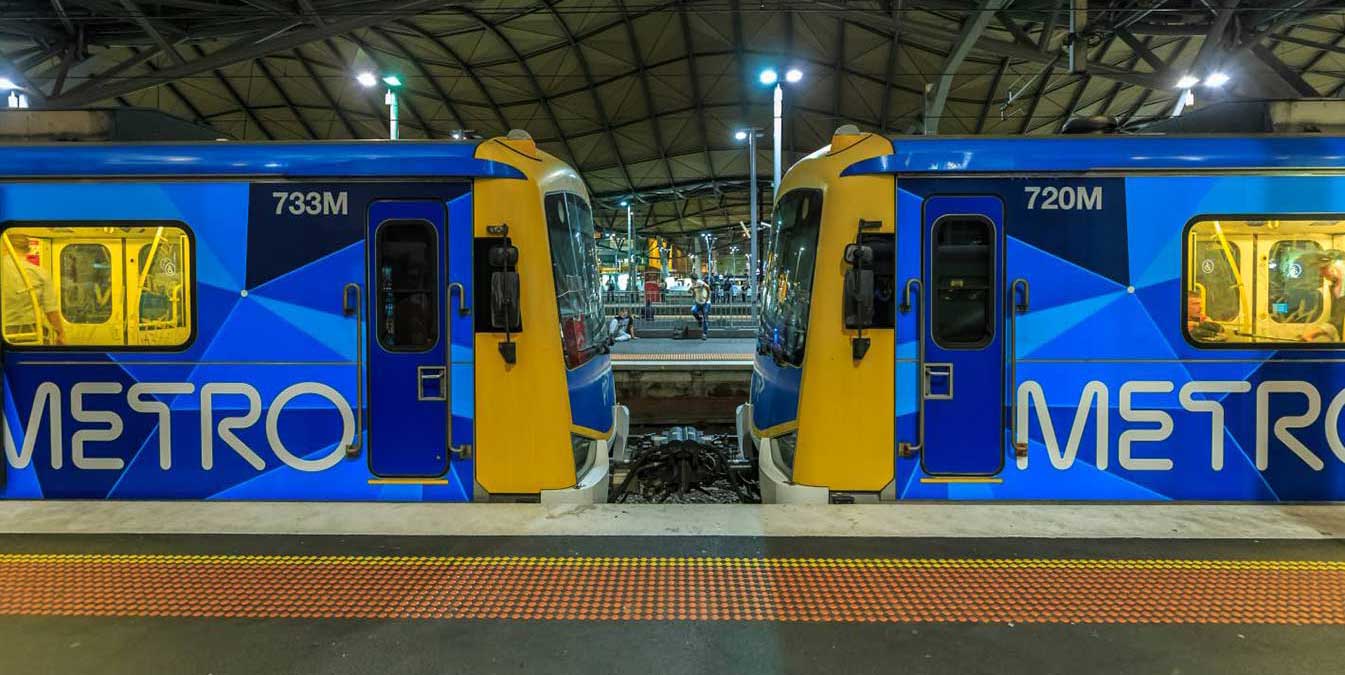
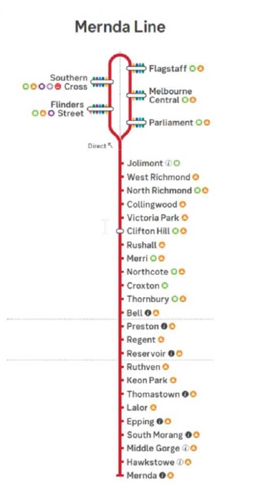
The line runs from Flinders Street station in central Melbourne via Southern Cross, Flagstaff, Melbourne Central, Parliament and Jolimont to Mernda station in the north, serving 29 stations including Clifton Hill, Reservoir, Epping, and South Morang. The line operates for approximately 19 hours a day (from approximately 5:00 am to around 12:00 am) with 24-hour service available on Friday and Saturday nights. During peak hour, headways of up to 7.5 minutes are operated with services every 10–30 minutes during off-peak hours. Trains on the Mernda line run with two three-car formations of X'Trapolis 100 trainsets.
The underground City Loop is at the centre of Melbourne's busy suburban railway system. It's quite an unusual design, being made up of four completely independent single track tunnels, some of which change direction half way through the day. From Flinders Street station, trains travel across the Flinders Street Railway Viaduct to Southern Cross Station. Upon leaving Southern Cross, trains travel underground through Flagstaff. Melbourne Central and Parliament stations, emerging from the underground loop at East Melbourne.
Jolimont is a residential precinct in East Melbourne, 1.5 km. from the GPO, Melbourne. In 1839 Charles Joseph La Trobe arrived in Melbourne as the Superintendent of Port Phillip. He brought a transportable dwelling and was obliged to buy land on which to erect it. Jolimont developed into a quiet residential precinct, until 1889, when a warehouse was erected in Agnes Street, and ten years later it became the Bedggood Boot Factory.
In 1887 a railway line was laid along the wide Wellington Parade reservation, and the Jolimont station was opened in 1901. A major railway yard was developed alonside the line. Located between Flinders Street station, Richmond Junction, the Yarra River and Flinders Street the yard and associated workshops were used to service and store suburban passenger trains. Often criticised for cutting off the city from the river, it was sybject to many redevelopment proposals. The rail sidings were progressively removed from the 1980s to the 1990s with only running lines today, but the area continues to be referred to as the 'Jolimont railyards' by Melburnians, however the railway interchange located there today is actually called Richmond Junction.
Jolimont station, which lies beyond the junction on Wellington Parade, East Melbourne, was opened on 21 October 1901 when a direct railway line was provided between Princes Bridge station (located on the site of Federation Square) and Collingwood. Jolimont is one of two stations that are close to the Melbourne Cricket Ground (MCG), the other being Richmond. During events at the MCG, extra exit gates are open to reduce crowding. The original timber station building was manufactured in England in 1899. In the late 1920s, it was sold and re-erected in Canberra, on the site of the present Jolimont Centre.
The Mernda line passes through the Jolimont Tunnel under Freeman Street and the West Richmond Tunnel under Hoddle Street. Most road users or pedestrians wouldn't know that they going over these tunnels. Before their construction in 1901 the only access was via the Inner Circle line.


West Richmond railway station serves the inner eastern Melbourne suburb of Richmond, and it opened on 21 October 1901. The station opened along with the line from Princes Bridge to Collingwood. Richmond, 3 km. east of Melbourne, has been a residential, industrial and residential, and latterly a more residential, suburb. Its western boundary, Punt Road, adjoins Melbourne city and its eastern boundary is the Yarra River, across from leafy Hawthorn. Richmond has a prominent hill on its western boundary, known as Richmond Hill but also as Dockers Hill. It is surmounted by four church spires. The land falls away to the river in the east, to the Collingwood flat in the north and to the flat land of Burnley n the south.
North Richmond, opened on 21 October 1901, is an elevated station with two side platforms, each with a pebbledash station building. It serves the western end of the Melbourne suburb of Richmond. Between West Richmond and Clifton Hill stations, the line follows Hoddle Street on it eastern side.
Collingwood is one of the oldest suburbs in Melbourne, notable for its historical buildings, with ornate, historic public buildings, cottages, terraces, shops, warehouses and factories still in use. Once a not-so-family-friendly part of town, known more for being the stomping ground of infamous gangsters like Chopper Read, Collingwood has had an extensive makeover, transforming it from a characterful, sometimes sketchy, suburb into an artsy, stylish neighbourhood with a thriving bar and dining scene.
These days Collingwood is about award-winning restaurants, great bars, galleries and mid-century furniture stores. The busy nightlife and close proximity to the city has attracted the independent types, the majority being young singles or more mature and older people living an inner-city lifestyle. Its redidents are comfortable with compact, convenient living, with housing ranging from workers cottages, bluestone terraces, Housing commission high-rises, converted factories housing designer apartments and live-in warehouses, to new contemporary units and townhouses.
Victoria Park station takes its name from a sports venue in the suburb of Abbotsford. The stadium is oval shaped and was built to host Australian rules football and cricket matches. In the past Victoria Park featured a cycling track, tennis courts, and a baseball club that once played curtain raisers to football matches. At its peak, from 1959 to the late 1980s, Victoria Park was the third largest of the suburban VFL stadiums after the Melbourne Cricket Ground and Princes Park. The ground is made up of
Victoria Park station opened on 8 May 1888 and, until 1901, the station was the terminus of the Collingwood to Heidelberg railway line. Until a direct connection with the Melbourne CBD was opened in 1901 between Princes Bridge and Collingwood Town Hall, the only connection to the city centre was via the indirect Inner Circle line.
Clifton Hill is a residential suburb 4 km north-east of Melbourne, separated from Collingwood by Alexandra Parade and the Eastern Freeway. An early landowner, better known in Richmond, was John Docker, who owned Clifton Farm in 1841. A land speculator, John Knipe, later named the area Clifton Hill.
The Melbourne City Council operated a basalt quarry in Clifton Hill, between Yambla Street and the Merri Creek, in the 1850s, continuing until the 1950s. Most of the other land was held by the Crown for agistment purposes, and Government land sales began in 1864. Residential settlement ended the use of Clifton Hill for the burial of sewage in the 1870s. The railway line only connected Collingwood and Heidelberg until a link between Princes Bridge and Collingwood was opened in 1901. A local shopping strip grew along the tramline on Queens Parade.
Rushall railway station, which serves the north-eastern Melbourne suburb of Fitzroy North, opened on 1 January 1927. Named after a nearby street, itself possibly named after a housing development in 1869. Rushall was also a station on the former Inner Circle line, which operated between Clifton Hill and Royal Park until July 1948. Rushall is located next to the Merri Creek, and is connected to Westgarth by a narrow, 80-metre-long footbridge for pedestrians and cyclists, crossing the Merri Creek as part of the Merri Creek Trail.
Melbourne indie band Underground Lovers wrote a song named Rushall Station, about the quietness of the site, which then became the title track for an album. The station is also mentioned in Marcel Borrack's song Ruthven to Rushall.
Merri is a railway station located in the suburb of Northcote, on the Epping/Mernda railway line. Merri station opened on October 8, 1889 as Northcote when the Inner Circle line was extended from North Fitzroy to Reservoir. The original conception of the station was to act as a major junction in a planned "North Suburban Railway System. It was renamed Merri in 1906.
The station derives its name from Merri Creek, a waterway which flows through the northern suburbs of Melbourne. It begins near Wallan and flows south for 70 km until joining the Yarra River at Dights Falls. The area where the creek meets the river was traditionally the location for large gatherings of the Wurundjeri people and is suspected to have been the location for one of the earliest land treaties in Australia between Indigenous Australians and European settlers.
Northcote is a residential and industrial suburb 8 km. north-north-east of Melbourne. Until 1994 it was a municipality, bounded on the west by the Merri Creek and on the east by the Darebin Creek. The Northcote township was surveyed in 1853 immediately north of a bend in the Merri Creek where Westgarth is now situated. It is now thought that the name Northcote was bestowed by the Surveyor-General, Sir Andrew Clarke, possibly as a compliment to Stafford Henry Northcote, barrister, private secretary to Gladstone and co-author of the famous Northcote-Trevelyan report on the reform of the British civil service (1853). Until the land-boom 1880s, Northcote remained rural, with occasional mansions or large homes. It was beyond the ring of metropolitan development before the land boom.
Croxton is a residential area in Northcote and Thornbury 7 km. north-north-east of Melbourne. It is best known for the Croxton Park Hotel in High Street, which was established in 1850-1 as the Old Pilgrim Inn, which was the first hotel opened in the Northcote district. In 1865 a new proprietor of the Pilgrim Inn put aside an adjoining site for athletic contests and horse riding, and in 1869 a syndicate of new owners named the establishment Croxton Park, said to be the name of a fashionable English racing rendezvous. Croxton Park was between high Street and St. Georges Road.
The Croxton Park's racecourse, called the Fitzroy Racecourse, was opened on the other side of St. Georges Road in 1891, becoming one of John Wren's pony tracks. It was closed in 1931 and remained a wasteland until taken for postwar housing.
Thornbury is 7 km north from Melbourne's central business district. Thornbury station, like the suburb itself, is named after the Thornbury Park Estate, named after a farm owned by settler Job Smith. He named the farm after his birthplace in England. For 111 years Thornbury was part of the former local government area, the City of Northcote, which existed from 1883 until 1994. Thornbury railway station is an unstaffed status ground structure station featuring two side platforms. It opened on 8 October 1889.
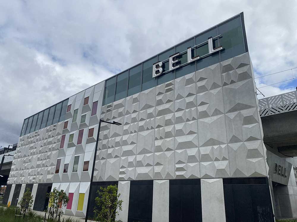
Bell railway station iserves the northern Melbourne suburb of Preston, and it opened on 8 October 1889 as Preston-Bell Street. It was renamed Bell on 1 August 1905. Opening on 8 October 1889, when the Inner Circle line was extended from North Fitzroy to Reservoir. Bell station is named after nearby Bell Street, itself named after Francis Bell, a landowner in Coburg who had a property named Bell Manor. he station once had a goods yard, which was removed in 1986, leaving only a siding at the up end of the station.
Preston, a residential and industrial suburb 9 km. north of Melbourne, was also a municipality from 1885 to 1994. The area was surveyed by Robert Hoddle and subdivided into farm allotments in 1837. The origins of Preston's settlement were generally along the Plenty Road, from Melbourne to the Plenty Ranges. In 1850 Edward Wood opened a store at the corner of High and Wood Streets, High Street branching off Plenty Road, it being being a route to Sydney.
Wood, who came from Sussex, England, is though to have given the name Preston, after Preston in Sussex. He was a founding member of the Baptist Church (1859). Hotels were established near Woods store and near the junction of High Street and Plenty Road, two kilometres to the south. Between these two localities is modern-day Preston central, known as Gowerville in the 1880s.
Regent railway station serves the northern Melbourne suburb of Reservoir, and it opened as Preston-Regent Street. It was renamed Regent on 1 August 1905. Named after the locality and nearby Regent Street, Regent station opened on 8 October 1889, when the Inner Circle line was extended from North Fitzroy to Reservoir.
Reservoir is a residential suburb 12 km. north of Melbourne and 2 km. north of Preston. Its named derives from three reservoirs built in 1864, 1909 and 1913, north of Preston to hold the metropolitan water supply from the Yan Yean reservoir. The reservoirs helped to settle sediment carried from Yan Yean and to reduce pressure on water mains which were prone to bursting. Being on the metropolitan outskirts and comprised mostly of small farms and low income families, Reservoir's residents experienced more than usual hardship during the 1930s depression. Childhood illnesses reduced school attendances and economic hardship lasted until the outbreak of the second world war. Residential development exploded in the early postwar years.
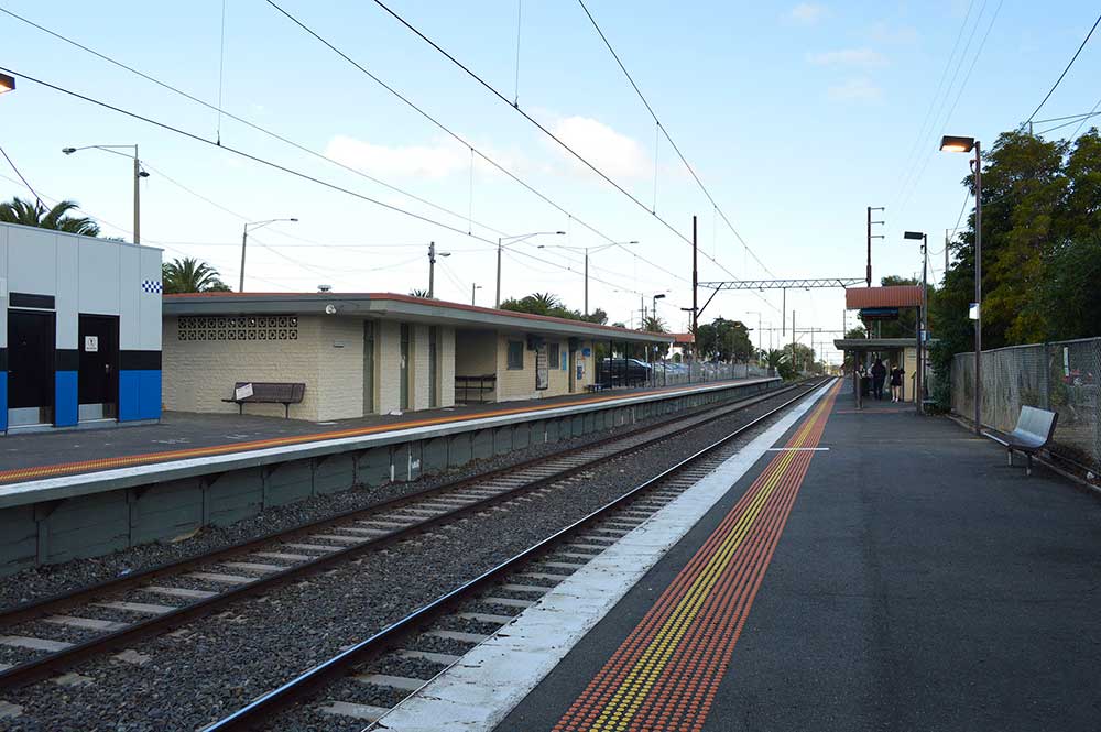
Serving the northern Melbourne suburb of Reservoir, Ruthven station opened on 5 August 1963, and was named after William Ruthven, who served in both world wars (winning the Victoria Cross in World War I). He was later a member of the Victorian Parliament, representing Preston and then Reservoir.
Keon Park railway station serves the northern Melbourne suburb of Thomastown. Opening on 16 December 1929, the locality, and more particularly the railway station of Keon Park, was named after Keon Park Pty Ltd., a land development company formed in 1924. The station opened at the same time as the extension of suburban services and electrification from Reservoir to Thomastown.
Thomastown is a residential and industrial suburb 15 km. north of Melbourne, with a station on the railway line to Epping. Unlike the land further west which is littered with basalt, Thomastown has fertile soil which was suitable for immediate settlement. William Westgarth purchased land to the north of the Thomas' holding, which he allotted to German settlers. It became Westgarthtown, in which the Lutheran church survives in Rosedale Drive. The German settlement had a school from 1856 to 1864.
The Thomastown district had a large dairy herd in the 1870s and attracted horse-racing and coursing by the Findon Hunt Club from Mill Park. The railway to Epping opened in 1889. Thomastown remained an agricultural area until the expansion of metropolitan Melbourne after the second world war, notwithstanding the opening of Fowlers pottery in 1928 and the electrification of the railway line.
Lalor is a postwar residential suburb 17 km. north of Melbourne in the north of what was formerly Thomastown. In 1946 a group of ex-servicemen, mostly with links with the labour movement, formed the Peter Lalor Home-Building Cooperative Society to provide cheap homes during a coming period of high demand and shortage of materials. (Peter Lalor was the leader of the Eureka Stockade rebellion in Ballarat, 1854.)
They chose land east of today's railway station, and engaged Saxel Tuxen, town planner, to design a garden suburb. Many streets are named after Victoria Cross winners. The Cooperative succeeded in beginning the house building but under-capitalisation resulted in the program being taken over by the War Service Homes Commission. The Cooperative's ambition to form a new community was not unlike the motive for Germantown (later named Wesgarthtown), partly in today's Lalor on the western side of the railway line. Lalor has expanded well beyond the Cooperative's land area.
Epping is a suburb 18 km. north of Melbourne, on the Darebin Creek. It is the terminus of a metropolitan railway line. An unnamed village reserve was surveyed in 1839 where Epping later developed. The village was named Epping in 1853, probably after Epping Forest, Essex, England, by when there were a hotel (1844) and a Catholic school. By the time the shire was created in 1915, Epping township contained several churches, hotels and a state school as well as church school. Farmers of Irish origin predominated, but English, Scots and Germans settled there. There were several dairy farms. The Melbourne to Whittlesea railway (1889-1960) had a station at Epping, and the main areas to benefit were the transport of milk and quarry products.
One of Melbourne's many shopping centres, Pacific Epping, is located 500 metres (550 yd) away from the Epping railway station. The Northern Hospital adjoins it. Dalton Village is a small shopping centre which is located on Dalton Road in Epping.
South Morang is 23 km north-east from Melbourne's central business district. Its Local Government Area is the City of Whittlesea.The suburb is situated towards the northern end of the Plenty River Valley growth corridor which during the 1980s was projected to be a major region of new metropolitan settlement. South Morang is one of the fastest growing suburbs in Victoria. Its name derives from the Parish of Morang, which was named after an Aboriginal word thought to mean cloudy or sky. What might have been North Morang in fact is Mernda.
The first station on the site was Rail Motor Stopping Place No. 39, at the McDonalds Road level crossing on the former Whittlesea line, with a South Morang station a short distance further on. In its final years of operation, the passenger service was provided by a diesel electric railmotor (DERM).
On 29 November 1959, the Victorian Railways closed the steam-era line north of Lalor, following the electrification of the line from Reservoir to Lalor. The line to Epping was electrified and re-opened on 29 November 1964, and the remaining section of track from Epping to Whittlesea dismantled, although the former right-of-way was left intact. In 2010 the extension of the Epping line was commenced to the site of Rail Motor Stopping Place No. 39, on the border of South Morang and Mill Park, about two kilometres short of the original South Morang station. On 22 April 2012, the new station was opened to the public.
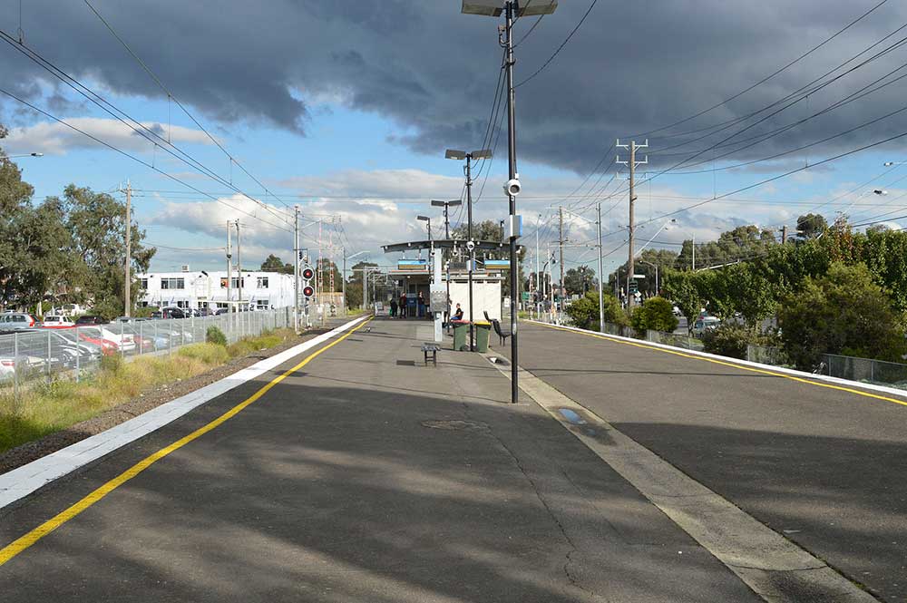
Middle Gorge railway station takes its name from Middle Gorge Park, a small recreation park located on the edge of the Plenty River. It offers views of the volcanic Plenty Gorge and its river frontage. The loop walking track follows the natural bush surroundings of the Plenty Gorge and River. Serving the suburb of South Morang, Middle Gorge railway station opened on 26 August 2018. It is the only station between South Morang and Mernda that is not elevated. It is also the only station between Thomastown and Mernda that does not have an island platform.
Hawkstowe station opened on 26 August 2018, when the railway line was extended from South Morang to Mernda, as part of the Mernda Rail project. The station was not originally planned as part of the project. However, as a result of pressure from the community, the station was included in the plan for the extension. It is elevated, providing views of the surrounding area, including the adjacent Plenty Gorge Park. The name of the station comes from a nearby property named Hawkstowe, once owned by J.H. Walker, who was the founder of Walker's Biscuits.
Mernda, on the edge of metropolitan Melbourne, is 26 km. to its north. Originally known as Morang until 1893, then South Yan Yean, the name Mernda was given in 1913 to distinguish the locality from the Yan Yean reservoir and picnic grounds. The name Mernda is derived from an Aboriginal word thought to mean earth. When Mernda was named in 1913 it had a school, a Methodist church, a store, a railway station and a mechanics' institute. Mernda had several dairy farms for metropolitan milk supply. A live stock sale yards operated beside the Bridge Inn, which had been built in 1841.
Mernda today consists of a number of new and developing housing subdivisions offering the new communities of Mernda Villages, Settlers Hill, Everton Gardens, Bridge Inn Rise, Berry Lane, Mernda Ridge, Woodland Waters, Hawkstowe, Riverdale and Renaissance Rise. Mernda is located just a 10-minute drive to Westfield Plenty Valley Shopping Centre and Pacific Epping. The 4000 square metre Mernda Villages Shopping Centre is located at the corner of Kalkallo Way and Mernda Village Drive. Mernda Junction Shopping Centre opened in February 2019, the Woolworths-led Mernda Town Centre opened on 27 October 2022.
On Sunday 26th August 2018 Melbourne's newest railway line opened with the Mernda rail extension taking its first passengers. The 8km extension of the from South Morang was built at a cost of around $600 million, brining passenger trains to Mernda for the first time in almost 60 years.


Design by W3layouts