


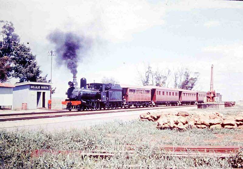
Belalie North railway station, 9 October 1967. Photo: Australian Railways Historical Society
belalie-north-station
In 1870, when the small town of Georgetown was developing as service centre for the surrounding wheat properties, it was known as Belalie, the same name as the nearby creek, which was the Aboriginal name for either the location or the creek. When the township was surveyed in 1871, its name was changed to Georgetown, after the James Fergusson, the Governor of SA, 1869-72.
Early pastoralist Daniel Cudmore of Ireland took out the Yongala pastoral run in the 1847 covering an area of 42 square miles. He added another 33 square miles to this run in 1854. He made a fortune from the Yongala run and it became a major pastoral estate. The government resumed the run in 1870 for closer settlement and McCulloch was left with just 11 square miles. Not to be outdone, McCulloch bought most of the subdivided land and maintained his pastoral interests. The Hundred of Yongala was declared in 1871 with Yongala town gazetted in 1876 and the first farmers settling near the town in 1872. McCulloch's property was subdivided after his death and Canowie Belt and Belalie North were created in 1902.
The tiny settlement we now know as Belalie North grew when the railway line from Port Pirie to Peterborough (then Petersburg) passed through the area in 1880. The railway station here was the highest station in South Australia at over 2,000 feet above sea level. The next highest was Gumbowie siding between Terowie and Peterborough. From 1886, the steam trains carrying goods to and from Broken Hill had to struggle to climb the big hills into Belalie North from Jamestown.
From 1871, farmers had started settling the land west of where the railway tracks would be laid. Schools, stores and churches were built, but the town we know of as Belalie North was created in 1902. The town was located where several roads met beside the railway line, and to the locals it was known as Belalie Summit. A stone Assembly Hall was built in 1908 and it then became the state school room (and the 1884 school closed) and it was used for the Methodist Church services. The old church and school to the west of Belalie North were later demolished. A commemorative plaque and stone mark the spot.
The opening of the new standard gauge railway line to Broken Hill in 1969 meant trains would bypass Belalie North to avoid the steep gradients up to the summit. In preparation for that change, the railways moved the workers and their houses and the weatherboard station in 1968. As a result, the government closed Belalie North School in that year and the town lost most of its population. The last train passed through Belalie North in 1970.
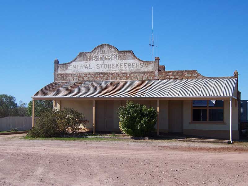
The general store frequented by mens outfitter RM Williams as a child is one of the few buildings still standing at Belalie North
Belalie North’s most famous son was R.M Williams who was born and raised here but he attended school at Loudon Brae. He went on to found the boot and later clothing stores and manufacturing in nearby Jamestown. Stores bearing his name are found around Australia and overseas. Another famous son of Belalie North was Thomas Edmonds who attended school here. He went on to train as a teacher, became deputy headmaster of Westminster College and then developed his singing career from 1968 onwards. He won singing awards, sang in England and Europe and made many record albums.
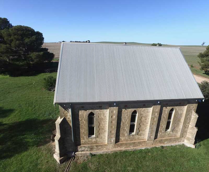
Former Belelie East Presbyterian Church
Belalie East
Belalie East was the long established local name for the rural locality when its boundaries were formally established in April 2001; however, the modern locality is divided between Belalie and the adjacent Hundred of Whyte. As an incentive to open up farming in the state's mid-north in the late 19th century, the government created groupings of essential facilities - schools, churches, a post office and a hotel - throughout the region which were never intended to be towns, but centres around which pioneering families could congregate and create communities. Belalie East and neighbouring Canowie Belt were two such localities.The Wilkins Highway runs roughly diagonally through the centre of Belalie East, connecting Jamestown and Hallett. The Belalie East school opened in 1878 and closed in 1959. The Belalie East Memorial Hall opened on 1 September 1923, and survives today. A Presbyterian church was built in 1881; its date of closure is unknown. It also formerly had its own coursing club. Belalie East has had three post offices, the third surviving until its closure in 1898.
The historic Coolootoo Shepherd's Hut, a remnant of the significant Old Canowie Station, is located on the boundary between Belalie East and its southern neighbour Mayfield, and is listed on the South Australian Heritage Register. Canowie Station was a former pastoral lease located about 18 kilometres north west of Hallett and 23 kilometres south west of Terowie. The former station was situated midway between Hallett and Jamestown in an amphitheatre of green bald hills, the north-south trending Browne Hill Range surrounding it on the western side, the eastern opening out into a broad valley. The country around is bare of timber, with the exception of plantations of various kinds of eucalypt planted around 1880. The estate consisted principally of rich land, well suited for agriculture, about 60,000 acres in extent, freehold, and depastured 60,000 sheep and about 1000 pure Shorthorn cattle.
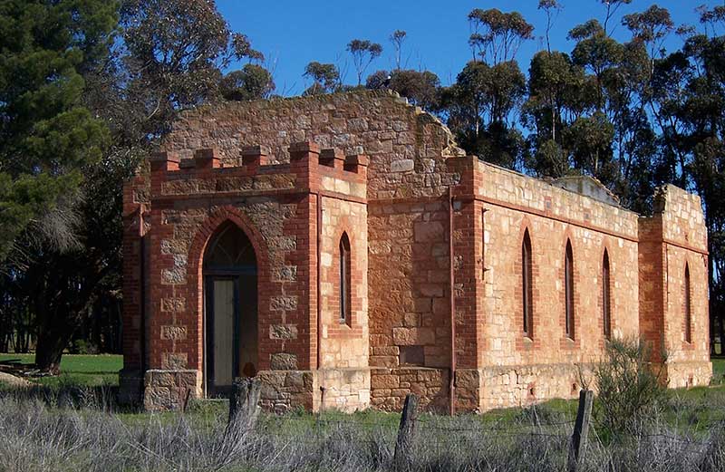
Ruins of the Canowie Belt Baptist Church
Canowie Belt
Canowie Belt consisted initially of several churches and public hall (built 1909), but in two seperate locations some miles apart, to service the farming families in the area. The Baptists erected a fine stone church in 1918. It closed in 1964 and was used by a local farmer for storage of old vehicles and equipment. The roof has now gone and the building is in ruins. The Presbyterians erected a tin church in 1908 directly opposite the Canowie Belt government primary school (now a residence). The school was built in 1904 but schooling began in 1901 at Canowie Belt in the Yongala Station woolshed.A small stone Lutheran church was built to the west of the pine trees near the crossroads at Canowie Belt in 1912. It closed in 1966 but has since been demolished. No other public and only one private building was ever erected at Canowie Belt.
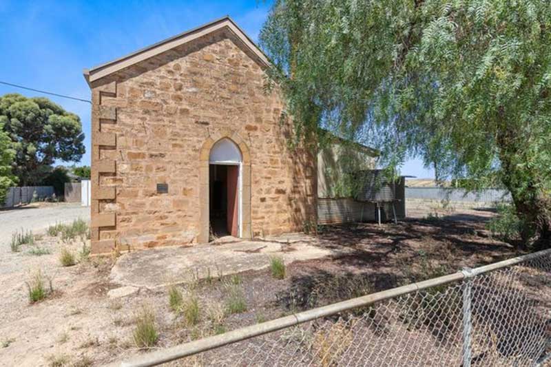
The new Methodist Church at Belalie North, opened 1st December, 1923. It is now a residence.