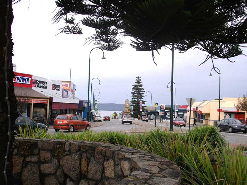
A major seaport for Western Australia's the Great Southern region, and the largest centre in Western Australia outside the metropolitan area, Albany is the perfect base from which to explore the many beauty spots - both coastal and inland - of the Great Southern.
Where is it?: Albany is 409 km south east of Perth on the Albany Highway. Albany is 481 km west of Esperance on Western Australia's south coast.
Albany has a cooler climate to Perth, and because of its location, it can be quite cold in Winter when the winds blow straight off the Southern Ocean. Spring and early summer (September to December) is when the wildflowers are in full bloom; July and October is the best time for whale watching. If you are prepared to risk the chance of bad weather, there are some great accommodation deals on offer during whale watching season. Summer (December to February) is annual vacation time for Western Australians, many of whom travel south to escape the hot Perth summer, so the place can be jumping with visitors in those months.
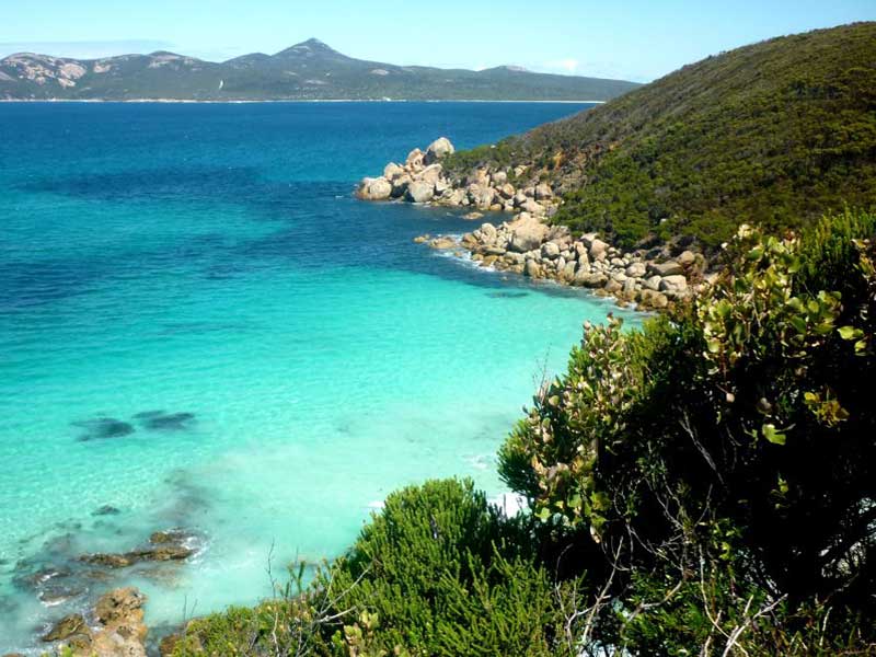
Sited on the shores of one of Australia's great natural harbours, Albany has long been a holiday destination for Western Australians, being surrounded by stunning coastal scenery, calm harbour beaches and beautiful mountains ranges in the hinterland with easy access walking tracks.
Albany's main street seems to go straight into the Princess Royal Harbour, as if to warn visitors that this is a place full of surprises. On its shore is Australia's last operating whaling station that is now an excellent museum dedicated to whales and whaling. Humpback and Southern Right whales still come to Albany, and are often seen between July and October in the calm waters off Middleton Beach. They play a while in the surrounding waters before migrating north to the warmer waters to breed. Stunning coastal scenery is just minutes away from the museum on a superb stretch of dramatic coastline weathered by the timeless forces of the Southern Ocean.
With a population of approximately 30,000 people, Albany is one of the larger towns of regional Western Australia and the main service and administrative for the Great Southern region. Unlike anywhere else in southern Western Australia, it rains a lot, 942 mm per year to be exact and in winter it can also get quite cold when the winds from Antarctica blow straight off the ocean. A wind farm that takes full advantage of the locality, welcomes visitors and has good signage to explain this eco-friendly technology.
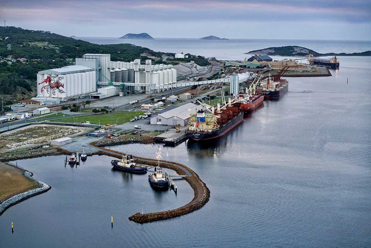
Photo: Southern Ports
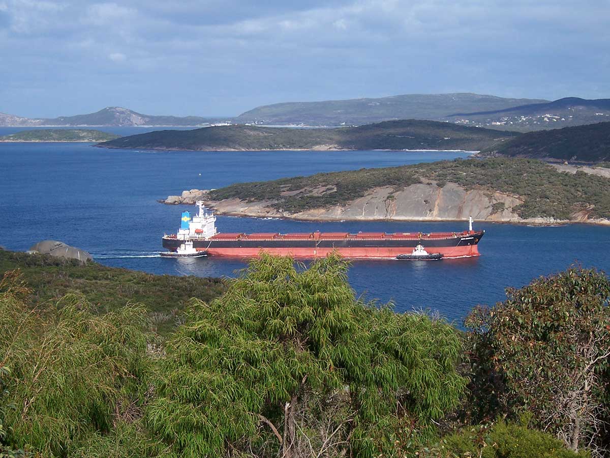
The Port of Albany has been a thriving trade hub since 1826, when it was the first and only deep-water port operating in Western Australia. Today, the Port continues to generate social and economic benefits for Albany and the rest of Western Australia – offering employment opportunities for locals while boosting the broader economy through its robust import and export activities. Three to four million tonnes of import and export material pass through the Port of Albany every year. Bulk products, such as grain, woodchips and silica sand make up the majority of exports, while fertiliser and fuel are the Port’s primary imports.
Around Town

Hidden away in Albany's suburbia is The Old Farm at Strawberry Hill. It is thought that the cottage may be the oldest building in Western Australia. Listed as part of the National Estate it is regarded as one of the most important buildings in the State.
The Old Farm dates from 1827, when the site was used as a vegetable garden and to cultivate maize to supply the small military detachment established at King George Sound. In 1831, Dr Alexander Collie, the first Government Resident, built a 'comparatively comfortable little dwelling house' close to the government gardens. This estate and the adjoining 43 hectares were purchased from the government in 1833 by Sir Richard Spencer. Wattle and daub additions were made to the original dwelling house c. 1834, and sheds and stables were also erected in this period.
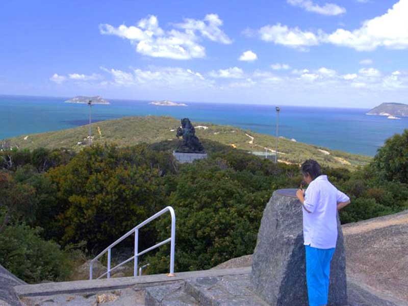
The peak of Mt. Clarence, behind the town of Albany, offers commanding views of the harbour. Mt. Clarence is the site of the Anzac Light Horse Memorial statue to Australia's fallen at Gallipoli. It was from Princess Royal Harbour in November 1914, that the thirty-eight ships of the fleet that carried Australian soldiers to war left Australia's shores.
For the thousands of Australian soldiers who died at Gallipoli, Albany was their last sight of their homeland. The massive and splendid bronze of a rampant horse complete with ANZAC rider was originally erected in Port Said. The base of the statue bears bullet marks from the Suez crisis in which it was damaged and is the reason why the statue was relocated to stand majestically against the sunrise over King George Sound.
British sea captain George Vancouver named the harbour after Her Royal Highness Princess Charlotte Augusta Matilda; whose 25th birthday it was on 29th September 1791, the day he sailed into the harbour and claimed the southern part of Western Australia for the British Crown. The site of his proclamation, at Possession Point on Vancouver Peninsula, forms the south-eastern shore of the harbour.
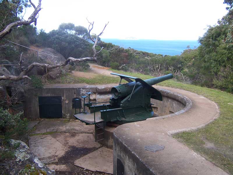
A pleasant bushwalk from the main road to Torndirrup National Park leads to the cairn which records the event. This strategic position led to the Princess Royal Fortress being built on Mt. Adelaide on the opposite shore in 1893, as the first Federal defence in Australia. The guns maintained their role as a deterrent until 1956 when the Forts were closed.The fortress still stands and houses an interesting military museum, complete with many original guns of the fortress.
Point Possession is a 1.6 km walk from Albany's old Quarantine Station to Point Possession where George Vancouver claimed the whole of Western Australia for Great Britain. It is located on the far side of Princess Royal Harbour on the way out to Torndirrup National Park with its dramatic coastal formations.
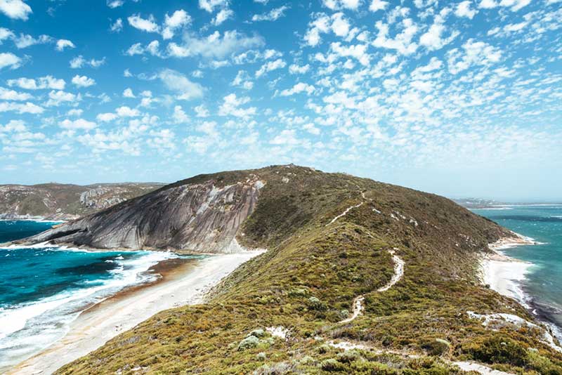
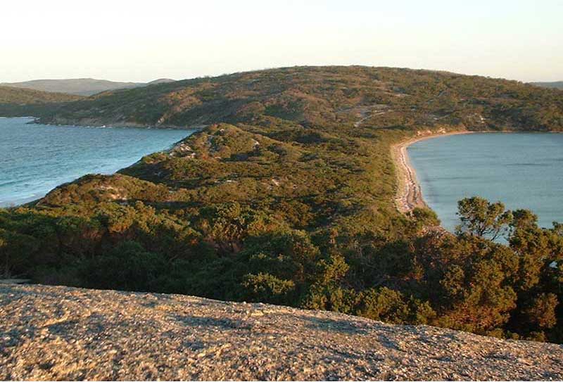
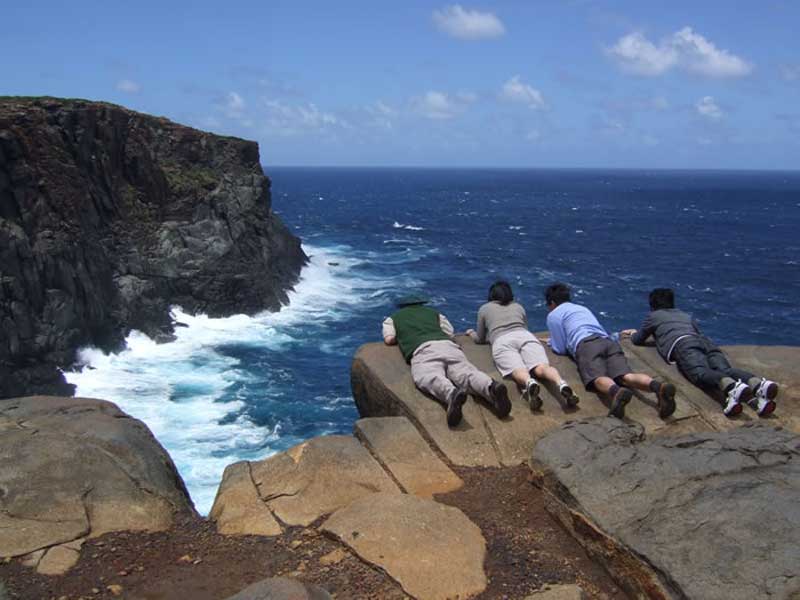
No visit to Albany could ever be complete without some hours spent in the Torndirrup National Park gazing in awe at the Natural Bridge, The Gap, the Blowholes, the Gorge, and Newles Inlet and visiting Whale World. Torndirrup National Park is renowned for its rugged coastal features such as the Gap and Natural Bridge.
There are many walking paths to the various natural features within the National Park which, in the main, are easy, relatively short walks. Be aware that this coastline has a notorious record for accidents due to people slipping and being washed into the ocean by unexpected freak waves or large swells, so take care and avoid going too close to the edge of cliffs.
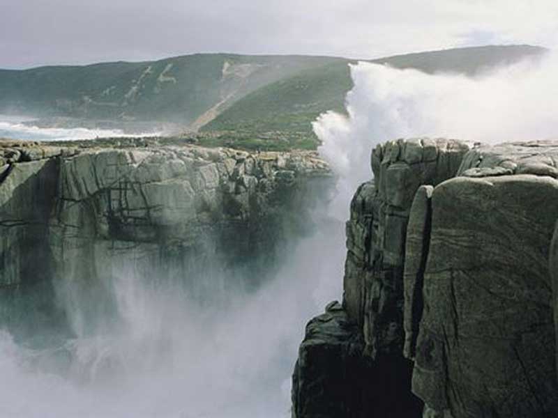
The Gap is sheer and dramatic, the Natural Bridge is fascinating, the views along the coast from the Natural Bridge are extraordinarily pretty and the view across Cable Beach (to the east of the Gap) is dramatic. The walk to the Blowholes can be disappointing if the sea is not running however the views from the coast are well worth the walk.
Jimmy Newell's Harbour: Nearby is Jimmy Newell's Harbour, a quiet little inlet which was named after a local fisherman who, caught by a sudden storm, was driven into the harbour where he found protection and safety.
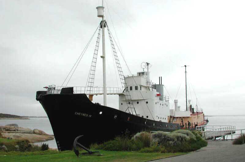
Whaling was Albany's (and indeed Australia's) oldest industry, so it is appropriate that the town's most popular museum is dedicated to the history of whaling in Australia. Whale World is housed in the former Cheynes Beach Whaling Station, located on the picturesque southern coast of King George Sound. The station ceased whaling operations and was de-commissioned in 1978. Whale World takes visitors on an interactive journey through the site, which was the last operating whaling station in Australia, supported by a series of audio visual displays, artefacts and whaling history. There are over 20 different exhibits including ‘Giants of the Sea’, the jaw dropping skeleton display. Outside visitors can climb aboard the Cheynes IV, a whale chaser that operated out of the Cheynes Beach Whaling Station, to experience a whale chase through audio re-enactment.
About half an hour’s drive south-west of Albany, West Cape Howe National Park contains the most southern point in Western Australia, Torbay Head. Almost completely covered in heathland and forest and bearing the force of the Great Southern Ocean, this National Park is worth a visit. At the Shelley Beach Lookout, platforms have been built into the side of the hilltop for hang gliders and paragliders to launch. Scenic bushwalking trails along the coast lead you through virgin bush and offer commanding views. Some of the best and remote walk trails are in the Torbay area – most are four or five hour return treks. Good sturdy footwear is recommended when hiking through this rugged wilderness area. Further east from West Cape Howe and shadowed by the giant trees of the south-west region are the towns of Denmark and Walpole.
This rugged mountain range rises spectacularly out of the surrounding plains. Located some 80km north of Albany, the Stirling Range National Park offers visitors a wonderful opportunity to explore an entire mountain range still in its natural state. World renowned for plant diversity, there are over 1,500 different flowers and plants including 125 orchids and 9 endemic mountain bells here in spring. Over 160 different birds have been sighted, including rare and endangered species. This rugged mountain range has something for everyone. The beautiful, ever changing scenery provides wonderful photographic and painting opportunities, and the mountain rock faces challenge the most experienced abseilers and rock climbers. The most climbed mountain in the Stirling Ranges is the chiselled mass of Bluff Knoll.
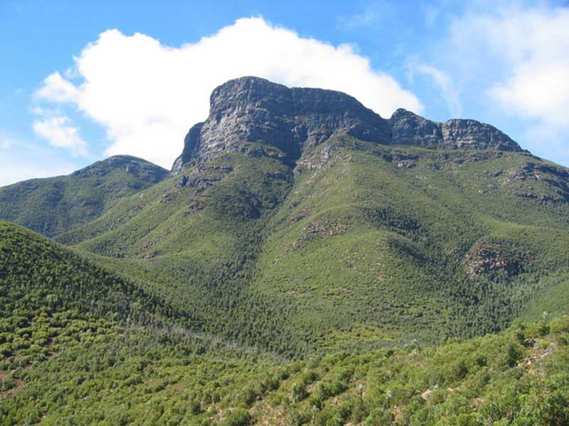
Bluff Knoll
At 1,095 metres above sea level, Bluff Knoll is the highest peak in the south-west of Western Australia. It takes three to four hours to complete the six-kilometre return walk/climb but it is worth it. It's a gruelling trek for those not used to mountain climbing, but achievable nonetheless. The views from the summit stretch across the craggy Stirling Range and south towards the Albany coast, and make every step worthwhile. Bluff Knoll is one of the few spots in the state to actually see some snow fall.
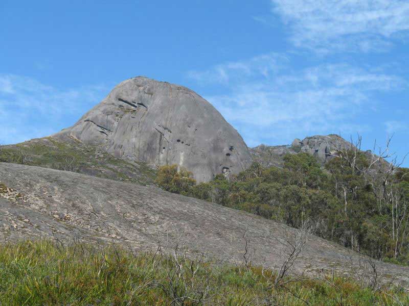
Gibraltar Rock, Porongurup Range
Although only 12 kilometres long and 670 metres at its highest point, the Porongurup Range is renowned for its beauty. It is clothed in a luxuriant forest of giant karri trees and the understorey puts on a brilliant display of wildflowers during spring and early summer. Pathway allow visitors to wander through the shade of ancient forests, discover fossils underfoot, see a rainbow of wildflowers, sit and listen to a symphony of bird songs, all with the magnificent views of the Stirling and Porongurup Ranges as your backdrop. 40 km north of Albany.
Only 35km east of Albany, the reserve is perhaps most important for being home to the critically endangered Gilbert’s potoroo and the endangered noisy scrub-bird, both of which were presumed extinct until being rediscovered at Two Peoples Bay.
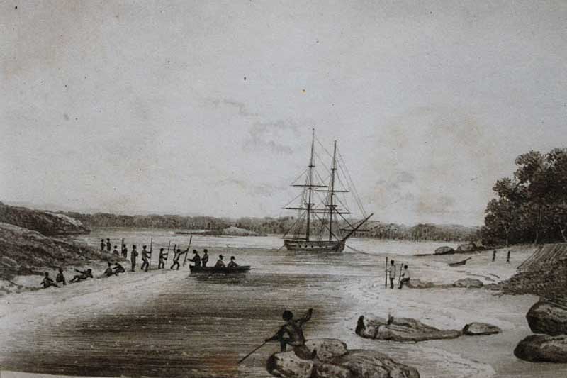
Contemporary sketch of George Vancouver meeeting the indigenous peoples of Oyster Harbour
Albany was established as a penal colony. The coastline had been sighted by Europeans as early as 1627 when Pieter Nuyts had sailed across the Great Australian Bight in the ship Gulden Zeepaardt. Nuyts' report of the land was such that the Dutch showed no interest in settlement. It was on the basis of the maps drawn by Nuyts that Jonathan Swift, when writing Gulliver's Travels, located the land of the Houyhnhnms almost exactly at the present site of Albany. With some kind of extraordinary vision Swift had Gulliver land on the coastline, eat oysters and be chased by Aborigines. He could not have known that George Vancouver, 65 years later, would enter one of the bays of King George Sound and name it Oyster Harbour because of the abundance of oysters he found in the area.
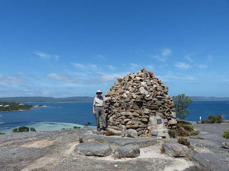
Cairn at Point Possession
The second European to visit the area was George Vancouver who entered King George Sound in 1791. Vancouver spent two weeks in the area during which time he named Bald Head, Breaksea Island, Michaelmas Island, Oyster Harbour, Seal Island, took possession of the area at Point Possession and declared 'This port, the first which we had discovered, I honoured with the name of King George the Third's Sound, and this day being the anniversary of Her Royal Highness Princess Charlotte Augusta Matilda's birth, the harbour behind point Possession I called Princess Royal Harbour.' Vancouver's report on the area was not good. He suggested that the soil was poor and the local Aborigines (he had not seen any of them) were extremely primitive.
The next explorer to visit the area was Matthew Flinders who arrived at King George Sound in July 1801 and he was followed by Nicholas Baudin who stopped in the sound on 11 February 1803 and stayed until 1 March noting the poor soils of the region but fascinated by the seemingly endless wildflowers. By the 1820s the area was being visited with some regularity by explorers and the whalers and sealers who worked in the Southern Ocean.
The turning point for Albany came on Christmas Day 1826 when the brig Amity entered King George Sound. The brig brought Major Edmund Lockyer and some troops and convicts. It had been decided some years earlier, partly to protect Australia against possible French settlement and partly because the British Government wanted to close the penal colony at Port Macquarie and open the surrounding area to free settlers, to establish Western Australia's first penal colony. Lockyer chose the site of present day Albany (a small stream ran into Princess Royal Harbour near where the replica of the Amity now stands) and it was officially proclaimed on 21 January 1827. At the time it was named Fredericks Town after Frederick Augustus, Duke of York and Albany, the second son of King George III.
Lockyer reported on the town site in April 1827. He made the observation that it was extremely difficult to sail from Sydney to Albany. He did however point out that, being the only deep water harbour on the south western coast it was very important strategically. Events overtook these limitations when, in 1829, a colony was established on the Swan River and its location, being superior to that of Albany, ensured its continuing existence and growing prosperity.
Albany never did become a penal colony. It remained nothing more than a military outpost of New South Wales until on 7 March 1831 it was proclaimed as part of the Swan River Colony (the previous year a small group of explorers had travelled overland from Perth to Albany) and later that year the town was surveyed and blocks of land were sold to free settlers. Any prisoners who had not completed their sentences were returned to New South Wales. The following year the name was changed to Albany. By 1836 maps of the town showed York Street running down to the harbour and Stirling Terrace sweeping along the harbour foreshore.
Perhaps the most fascinating of all Albany's early visitors was Edward John Eyre who, with his Aboriginal companion Wylie, arrived in the town on 7 July 1841 and stayed for a week at Skerrats Family Hotel on the corner of Stirling Terrace and York Street. There can be few more potent historical experiences than to stand on the corner and imagine Eyre, having just walked from South Australia across the Nullarbor Plain, standing on the corner of the tiny town 150 years ago. Eyre was hugely impressed by the warmth of greeting which the friends and relatives of Wylie gave the Aboriginal guide upon his arrival in Albany.

Design by W3layouts